Ausangate Mountain: Where Culture, Nature, and Adventure Meet in the Andes
Ultima actualización en 30 September, 2026 por Jhon Quispe
Last Updated on 30 September, 2026 by Jhon Quispe
What is Ausangate Mountain?
Ausangate Mountain, also known as Nevado Ausangate, is a 20,948-ft (6,385-m) glaciated peak in the Vilcanota mountain range about 75 mi (120 km) southeast of Cusco, Peru. It is the highest mountain in the Cusco region and is regarded as a sacred Apu in local Andean traditions. The standard Ausangate Trek travels around the mountain rather than climbing its summit.
- Ausangate Mountain at a glance
- What is Ausangate Mountain?
- Where is Ausangate Mountain in Peru?
- How high is Ausangate Mountain?
- Why is Ausangate considered a sacred Apu?
- Ausangate Mountain vs Ausangate Trek
- Landscape and wildlife around Ausangate Mountain
- Ausangate Regional Conservation Area
- How can you experience Ausangate Mountain?
- Best time to visit Ausangate Mountain
- High-altitude planning around Ausangate
- Common mistakes when planning a visit to Ausangate Mountain
- Choose the right way to experience Ausangate
-
Frequently asked questions about Ausangate Mountain
- How far is Ausangate Mountain from Cusco?
- Is Ausangate Mountain inside a protected area?
- Is the Seven Lakes hike the same as the Ausangate Trek?
- Can you see Ausangate from Pacchanta?
- Do standard Ausangate treks climb the summit?
- How high is the Seven Lakes of Ausangate route?
- Can you visit Ausangate without camping?
- Do some Ausangate treks connect with Rainbow Mountain?
The name Ausangate can refer to the mountain itself, the trekking landscape around it or the wider protected area. Distinguishing those three matters because the 20,948-ft summit, tourist trekking routes and conservation boundaries describe different things.

Ausangate Mountain at a glance
| Detail | Planning reference |
| Name | Ausangate Mountain / Nevado Ausangate |
| Location | Ocongate district, Quispicanchi province, Cusco, Peru |
| Mountain range | Vilcanota mountain range |
| Summit elevation | 20,948 ft (6,385 m) |
| Regional significance | Highest mountain in the Cusco region |
| Approximate distance from Cusco | 75 mi (120 km) southeast |
| Cultural significance | Sacred Apu for many local Quechua communities |
| Standard trek | Travels around the mountain rather than climbing the summit |
| Summit climb | Technical high-altitude mountaineering objective |
What is Ausangate Mountain?
Ausangate Mountain, also known in Spanish as Nevado Ausangate, is a glaciated peak in southern Peru’s Vilcanota mountain range. At 20,948 ft (6,385 m), it is the highest mountain in the Cusco region.
The name Ausangate is also commonly used for the high-Andean landscape surrounding the mountain and for trekking routes that pass through nearby valleys, lagoons and mountain passes. These uses are related, but they are not the same thing.
For travelers, Ausangate can therefore mean several different experiences: seeing the mountain from Pacchanta, hiking around the Seven Lakes, completing a multi-day trek around the massif or attempting the technical summit as a separate mountaineering expedition.
Where is Ausangate Mountain in Peru?
Ausangate Mountain is located in Ocongate district, Quispicanchi province, in the Cusco region of southern Peru. It lies approximately 75 mi (120 km) southeast of Cusco within the Vilcanota mountain range.
Ocongate, Tinki and Pacchanta are important reference points for travelers approaching the Ausangate area. Pacchanta in particular provides mountain views, access to thermal pools and a starting area for shorter high-altitude hikes.
The mountain itself should not be confused with the entire Ausangate Regional Conservation Area, which protects a much broader high-Andean landscape extending across several districts.
How high is Ausangate Mountain?
Ausangate Mountain reaches 20,948 ft (6,385 m) above sea level. This makes it the highest mountain in the Cusco region and places its summit far above the elevations reached on normal tourist trekking routes.
The summit elevation is sometimes confused with the maximum altitude of the Ausangate Trek. Standard trekking routes cross high mountain passes around the massif, but they do not normally climb to 20,948 ft.
Keep this in mind:
Seeing Ausangate Mountain, trekking around the massif and climbing the 20,948-ft (6,385-m) summit are three different experiences with very different physical and technical requirements.
Why is Ausangate considered a sacred Apu?
For many Quechua communities around Ausangate, the mountain is an Apu, a sacred mountain associated within the Andean worldview with protection, water, fertility and the well-being of the surrounding land and communities.
Apu Ausangate in local tradition
The relationship with Apu Ausangate remains visible in pastoral life, ceremonies and local traditions. Communities in the region have long depended on high-Andean water sources, grasslands and livestock such as alpacas and llamas.
Traditional offerings known as despachos may include coca leaves, food, drinks and symbolic objects. These practices express reciprocity between people, Pachamama and the sacred mountain landscape.

Ausangate Mountain vs Ausangate Trek
Ausangate Mountain is the 20,948-ft (6,385-m) peak itself. The Ausangate Trek refers to hiking routes that travel through the valleys, communities, lagoons and mountain passes surrounding the massif.
| Experience | What it involves | Typical duration |
| See Ausangate Mountain | Viewpoints around Pacchanta and nearby roads | Part of a day |
| Seven Lakes of Ausangate | High-altitude hike through glacial lagoons near Pacchanta | Full day |
| Ausangate Trek | Multi-day hiking around the mountain through high passes | Several days |
| Ausangate summit | Technical climbing on a glaciated 20,948-ft (6,385-m) mountain | Mountaineering expedition |
The conventional trek does not reach the summit. For detailed route options, distances, mountain passes, difficulty and preparation, use the Ausangate Trek guide.
Landscape and wildlife around Ausangate Mountain
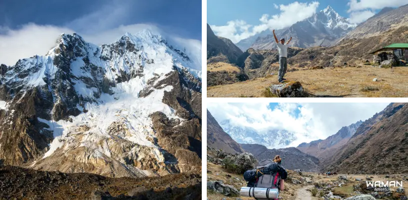
The landscape surrounding Ausangate combines glaciers, mountain lakes, puna grasslands, high passes and Quechua communities whose daily lives remain closely connected with alpaca and llama herding.
Glaciers and snow-covered peaks
Ausangate dominates a glaciated section of the Vilcanota range. Snow and ice remain visible around the upper mountain, although the amount and appearance of glacial cover can vary over time and by season.
Glacial lagoons
Several hiking routes pass lakes formed within the glacial landscape. Their colors can range from dark blue and turquoise to green or reddish tones depending on minerals, sediment, light and weather conditions.
Alpacas, llamas and high-Andean wildlife
Alpacas and llamas are common throughout the inhabited valleys. The broader high-Andean environment can also support vicuñas, vizcachas and Andean birds, although wildlife sightings are never guaranteed.
Quechua communities
Travel through the Ausangate region also passes communities such as Pacchanta, Upis and settlements around Ocongate. The landscape is therefore not an empty wilderness but a living pastoral environment.
Ausangate Regional Conservation Area
The Ausangate Regional Conservation Area protects a much broader landscape surrounding the mountain. It covers approximately 164,360 acres (66,514.17 ha) across Ocongate in Quispicanchi province and Pitumarca and Checacupe in Canchis province.
The protected area was established to conserve high-Andean puna ecosystems, glaciers, wetlands, biodiversity, water sources and the cultural landscape associated with Ausangate.
Important note:
Ausangate Mountain is one specific 20,948-ft (6,385-m) summit. The Ausangate Regional Conservation Area protects a much larger territory of approximately 164,360 acres (66,514.17 ha).
How can you experience Ausangate Mountain?
You do not need to climb the summit or complete an entire multi-day circuit to experience Ausangate. The best option depends on how much time you have, your acclimatization and the level of hiking you want.
Pacchanta
Pacchanta is one of the most practical bases for seeing Ausangate without completing the full trek. The community offers direct mountain views, local thermal pools and access to shorter hiking routes in the surrounding highlands.
This makes Pacchanta useful for travelers who want mountain scenery without committing to several nights of camping.

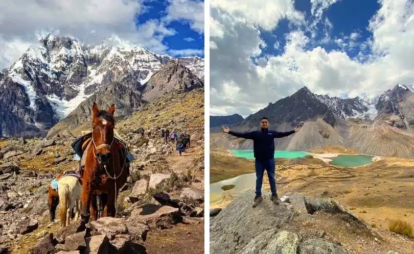
Seven Lakes of Ausangate
The Seven Lakes route is a high-altitude full-day hike beginning near Pacchanta. Waman’s current itinerary covers approximately 6.2 mi (10 km), includes around five hours of hiking and reaches about 15,420 ft (4,700 m).
The route is much shorter than the multi-day Ausangate Trek, but it should not be treated as an easy low-altitude walk. Acclimatization still matters.
For complete logistics and the current day-trip itinerary, see the Seven Lakes of Ausangate experience.
Multi-day Ausangate Trek
The multi-day trek provides the most complete hiking experience around the mountain landscape. Routes cross high passes, camps, glacial lagoons and remote valleys while keeping the 20,948-ft summit in view from different angles.
Some longer itineraries can also connect the Ausangate region with Rainbow Mountain and Red Valley. Route length, passes and difficulty vary substantially, so use the complete Ausangate Trek guide when comparing multi-day options.
Climbing the summit
Reaching the summit of Ausangate is not a normal trekking activity. The upper mountain is glaciated and requires technical mountaineering experience, specialized equipment and appropriate high-altitude support.
Travelers booking an “Ausangate Trek” should therefore not assume that the itinerary includes an ascent to the summit.
Best time to visit Ausangate Mountain
May through September is generally the drier period in the Cusco Andes and is commonly preferred for visiting and hiking around Ausangate. Days can offer more stable conditions, while nights at high elevation can become very cold.
| Period | General conditions | Planning note |
| May–September | Generally drier | Common hiking period with cold nights and strong high-altitude sun |
| April and October | Transition periods | Conditions can shift between drier and wetter patterns |
| November–March | Generally wetter | More cloud, rain and possible snow at higher elevations |
These seasonal patterns are useful for planning but do not guarantee specific conditions. Mountain weather around Ausangate can change quickly at any time of year.

High-altitude planning around Ausangate
Altitude affects almost every way of experiencing Ausangate. Even shorter hiking areas around Pacchanta can take travelers above 14,000 ft, while multi-day trekking routes cross substantially higher terrain.
Spending time acclimatizing before a demanding hike can make the physical effort more manageable. Fitness helps with walking uphill and carrying a daypack, but it does not guarantee protection from altitude illness.
Travel at a sustainable pace and pay attention to symptoms rather than assuming headaches, nausea, dizziness or unusual fatigue are simply part of the hiking experience.
Travelers with medical concerns related to high-altitude travel should discuss their plans with an appropriate healthcare professional before choosing a demanding route.
Common mistakes when planning a visit to Ausangate Mountain
- Assuming the standard Ausangate Trek climbs the 20,948-ft summit.
- Confusing Ausangate Mountain with the entire Ausangate Regional Conservation Area.
- Using the summit elevation as if it were the maximum altitude of every trekking route.
- Treating the Seven Lakes route as an easy low-altitude excursion because it lasts only one day.
- Assuming a shorter Ausangate experience does not require high-altitude preparation.
Choose the right way to experience Ausangate
Ausangate can be experienced as a mountain viewpoint, a Seven Lakes day hike or a demanding multi-day trek. Use the Ausangate Trek guide if you are comparing longer routes, review the Seven Lakes experience if you only have one day, or talk to a travel specialist if you want help matching the altitude and itinerary to your trip.
Frequently asked questions about Ausangate Mountain
How far is Ausangate Mountain from Cusco?
Ausangate Mountain is approximately 75 mi (120 km) southeast of Cusco in the Vilcanota mountain range. Actual driving distance and travel time depend on whether you approach through Ocongate, Tinki, Pacchanta or another trailhead.
Is Ausangate Mountain inside a protected area?
Ausangate is associated with the Ausangate Regional Conservation Area, a protected landscape covering approximately 164,360 acres (66,514.17 ha) across parts of Quispicanchi and Canchis provinces. The protected area is much larger than the mountain itself.
Is the Seven Lakes hike the same as the Ausangate Trek?
No. The Seven Lakes of Ausangate is a full-day high-altitude hike near Pacchanta. The Ausangate Trek refers to multi-day routes through valleys, camps and mountain passes surrounding the massif.
Can you see Ausangate from Pacchanta?
Yes. Pacchanta is one of the main local bases for viewing Ausangate Mountain and also provides access to thermal pools and shorter hiking routes in the surrounding highlands.
Do standard Ausangate treks climb the summit?
No. Standard trekking routes travel around Ausangate and cross high mountain passes, but they do not normally reach the 20,948-ft (6,385-m) summit. Summit climbing is a separate technical mountaineering objective.
How high is the Seven Lakes of Ausangate route?
Waman’s current full-day Seven Lakes route reaches approximately 15,420 ft (4,700 m). Although it is much shorter than a multi-day trek, it remains a demanding high-altitude hiking experience.
Can you visit Ausangate without camping?
Yes. Travelers can visit Pacchanta, enjoy views of the mountain, use the thermal pools or complete the Seven Lakes route without joining a multi-day camping trek.
Do some Ausangate treks connect with Rainbow Mountain?
Yes. Some multi-day routes through the wider Ausangate region can connect with Vinicunca, commonly known as Rainbow Mountain, and Red Valley. These should not be confused with the standard Rainbow Mountain day trip from Cusco.

Share:



Related tours you might be interested in
Enjoy unique experiences in Cusco and Machu Picchu with the peace of mind that comes from working with a local travel agency

Tour to Chinchero, Maras & Moray – Private Service
Discover with us this beautiful, charming and historic places, where we will visit the enigmatic...

2-Day Trip to Machu Picchu from Cusco with Machu Picchu Mountain
LIVE A UNIQUE EXPERIENCE EXPLORING THE BREATHTAKING LANDSCAPES ON A 2-DAY JOURNEY TO MACHU PICCHU...
6-Day Tour Cusco, Sacred Valley, Machu Picchu and Rainbow Mountain
EXPERIENCE THE MAJESTY OF THE INCAS: SACRED VALLEY, MACHU PICCHU & RAINBOW MOUNTAIN IN ONE TRIP If...

6 Day Andean Adventures Tour│With Flights from Chile
ENJOY THE BEST OF CUSCO CITY – MUST VISIT DESTINATIONS ARE WAITING FOR YOU! Want to explore Cusco...
If you liked this article and the information you found, give us 5 stars!
Table of Contents
Related blogs
Route of the Sun: Cultural Highlights Between Cusco and Puno
6 min of reading
Why is Rainbow Mountain in Peru Colorful? Geology Behind the Colors
8 min of reading
Discovering The Amazing History of Machu Picchu
13 min of reading