Ankasmarka Archaeological Site Near Calca in Cusco
Ultima actualización en 26 September, 2026 por Jhon Quispe
Last Updated on 26 September, 2026 by Jhon Quispe
What is Ankasmarka?
Ankasmarka, also spelled Ancasmarca, is a high-Andean archaeological site in Calca province, Cusco, along the road from Calca toward Lares. It sits at about 3,850 m (12,631 ft) and is known for hundreds of circular and ovoid stone enclosures associated with storage, domestic, workshop and funerary functions. The site is roughly 23 km (14 mi) from Calca. Plan about 1–2 hours to explore it and confirm local access before traveling.
- Ankasmarka at a glance
- Ankasmarka and Ancasmarca refer to the same archaeological site
- Ankasmarka location and how to get there
- What was Ankasmarka used for?
- What to see at Ankasmarka
- The Ankasmarka flood legend
- Planning your Ankasmarka visit
- Combining Ankasmarka with the Sacred Valley
- Plan an Ankasmarka visit around the Calca side of the Sacred Valley
- Frequently asked questions about Ankasmarka
Ankasmarka is much quieter than the major Sacred Valley archaeological parks, but its architecture tells a different story. Rather than monumental temples dominating the visit, the site helps explain how highland communities lived, stored goods and moved between the valley and the surrounding Andes.
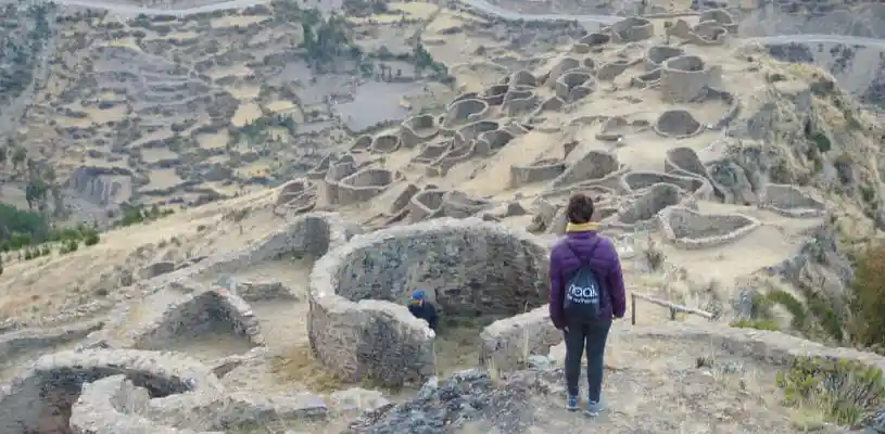
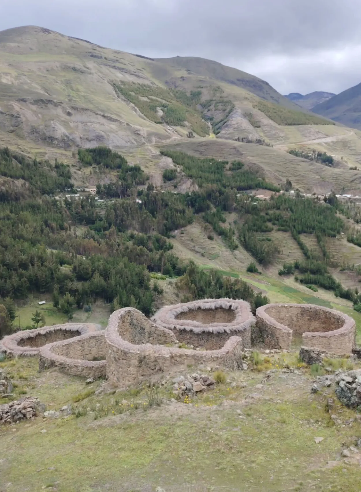
A visitor explores Ankasmarka’s circular enclosures above the Calca area.
Ankasmarka at a glance
| Detail | Planning reference |
| Also written as | Ancasmarca; both spellings refer to the same archaeological site |
| Region | Cusco |
| Province | Calca |
| Local area | Accha / Accha Alta area |
| Access route | Road from Calca toward Lares |
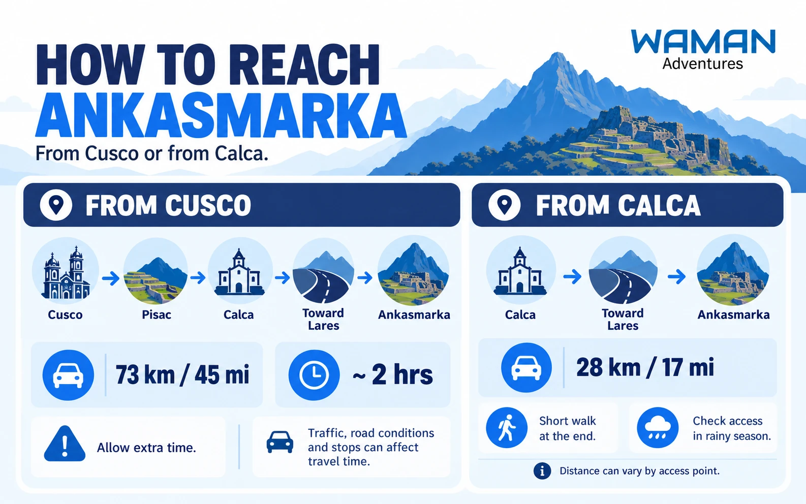
| Distance from Calca | About 17 mi (28 km) in the municipal planning reference; local access measurements can vary by starting point |
| Distance from Cusco | About 45 mi (73 km) according to PROMPERÚ travel information |
| Elevation | About 12,630–12,665 ft (3,850–3,860 m), depending on the reference point |
| Typical visit time | About 1–2 hours on site |
| Main features | Circular, ovoid and rectangular enclosures, storage areas, funerary sectors, paths and road remains |
| Visitor services | Limited; do not depend on shops, reliable restrooms or strong mobile signal |
Ankasmarka and Ancasmarca refer to the same archaeological site
You will see the site written as both Ankasmarka and Ancasmarca. Ankasmarka reflects a Quechua-based spelling commonly used locally, while Ancasmarca also appears in archaeological publications, maps and travel searches. Both names refer to the archaeological complex near Calca.
The meaning of the name is less certain. Published interpretations have connected its components with ideas such as an eagle, the color blue or a settlement or place. These should be treated as proposed Quechua interpretations rather than one definitive translation.
Ankasmarka location and how to get there
Ankasmarka lies in Calca province in the Cusco region, high above the main Sacred Valley floor near the Accha / Accha Alta area. The archaeological site is reached using the road that climbs from Calca toward Lares.
Its elevation of roughly 12,630–12,665 ft (3,850–3,860 m) places it considerably higher than Calca and much of the Sacred Valley. Weather, wind and physical effort can therefore feel different from the lower valley.
Visiting independently
You can visit Ankasmarka independently, but it requires more planning than major Sacred Valley sites such as Pisac or Ollantaytambo. Arrange your transport and return journey before leaving Calca rather than assuming vehicles will be waiting at the archaeological site.
Carry water, some cash and saved route information. Shops, reliable restrooms, guides and strong mobile data should not be assumed at the site.
Warning:
Ankasmarka sits above 12,600 ft (3,840 m). If you are not acclimated, walk slowly, hydrate and avoid turning a short archaeological visit into a strenuous hike.
What was Ankasmarka used for?
Ankasmarka should not be reduced to a group of Inca storehouses. Archaeological interpretations indicate a settlement with several overlapping functions, including domestic activity, storage, workshops, agriculture and funerary use.
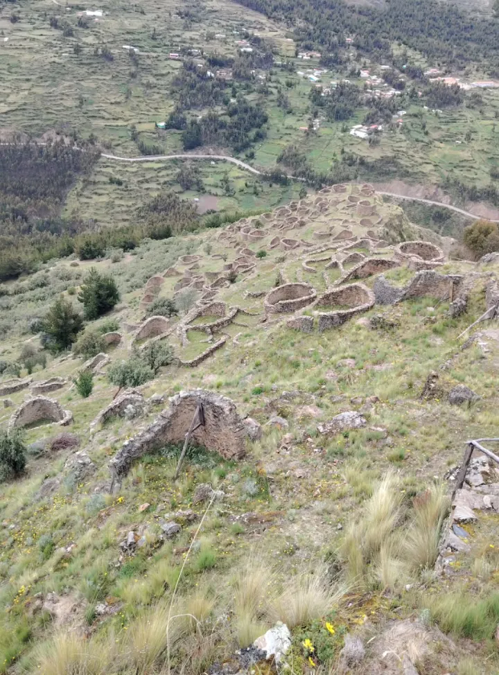
Published descriptions refer to several hundred structures across the archaeological complex, although counts vary depending on which sectors and types of remains are included. This is more useful than presenting one exact number as if every structure were identical or served the same purpose.
Evidence from the area spans the Late Intermediate Period and the Inca period. Parts of the settlement therefore existed or developed before and during Inca rule rather than belonging to a single construction episode.
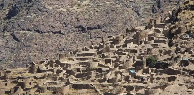
Circular and ovoid enclosures reveal the scale of the Ankasmarka settlement.
Circular enclosures and architecture
Many of Ankasmarka’s most visible structures have circular or ovoid plans and were built with local stone together with clay or mud-based materials. Small doorways and compact interior spaces appear repeatedly across the complex.
Other sectors contain rectangular structures, pathways and agricultural or terraced areas. The variation in architecture is important because it indicates that the settlement was not designed for one activity alone.
Storage, domestic and funerary functions
Some sectors have been associated with storage and are often compared with qolqas, the storage facilities used across the Andes for agricultural products and other goods. Local descriptions also connect storage activity with crops such as potatoes, corn and quinoa.
Other structures and sectors have been interpreted as domestic spaces, workshops or funerary contexts. Those distinctions provide a more accurate picture of Ankasmarka than describing every circular enclosure simply as an Inca granary.
What to see at Ankasmarka
- Circular and ovoid enclosures: the site’s most distinctive architectural forms.
- Rectangular structures: buildings associated with domestic or other activity areas.
- Storage sectors: spaces interpreted in connection with food and goods preservation.
- Funerary contexts: sectors archaeological interpretations associate with burial activity.
- Old paths and road remains: evidence of connections between the Sacred Valley and higher Andean zones.
- Terraced Andean landscape: broad views across cultivated slopes and highland terrain around Calca.
A local stream known as Cha’ipa runs beside part of the archaeological area, while traces of older routes remain visible in the surrounding landscape. These features help explain Ankasmarka’s position between lower agricultural zones and higher pastoral areas.

The Ankasmarka flood legend
One of the most distinctive traditions connected with Ankasmarka appears in the sixteenth-century writings of Cristóbal de Molina. In the story, llamas become distressed because they know a great flood is approaching. Their behavior alerts a shepherd, who gathers his children, food and livestock and climbs a high hill called Ancasmarca.
As the waters rise, the hill is said to rise with them and remain above the flood. After the water recedes, the hill returns to its place and the surviving family descends to repopulate the region.
Another version of the tradition describes the Creator warning a small number of respected people so they could seek refuge before the flood. These accounts belong to Andean oral tradition as recorded during the colonial period and should be understood as cultural narratives rather than archaeological explanations for the site.
Planning your Ankasmarka visit
Visit time and visitor services
Plan about 1 hour for a straightforward visit or up to 2 hours if you want more time for photography, interpretation and breaks. The archaeological visit itself is relatively short, but transportation from Cusco or Calca makes the overall outing considerably longer.
Visitor infrastructure is limited. Do not rely on finding a full visitor center, shops, dependable restrooms, ATMs or a consistent mobile signal beside the archaeological complex.
Altitude and weather
At more than 12,600 ft (3,840 m), Ankasmarka is significantly higher than much of the Sacred Valley floor. Strong sun, wind and rapid temperature changes can make conditions feel more demanding than they do in Calca below.
Drier conditions are generally more common from approximately May through October, while wetter months can affect road and walking conditions. Seasonal patterns are not guarantees, so check the forecast and local road conditions close to your visit.

Do not depend on mobile data for navigation once you reach the highland access area. Save essential directions before leaving Calca.
Keep this in mind:
Ankasmarka is a fragile archaeological site. Do not climb on walls, move stones, remove ceramics or other archaeological material, or enter unstable structures.
Combining Ankasmarka with the Sacred Valley
Ankasmarka fits most naturally into a day focused on the Calca side of the Sacred Valley. Pisac, Taray and Calca are geographically more logical companions than destinations on the opposite side of Cusco.
The best combination depends on where you are staying, whether you have private transportation and how much time you want at each stop. For broader regional planning, use the Sacred Valley travel guide rather than turning the Ankasmarka visit into a full valley itinerary.
Plan an Ankasmarka visit around the Calca side of the Sacred Valley
Ankasmarka works best when transportation is arranged before you leave Calca because it is not a major tourist hub with frequent return services. A short archaeological visit can therefore require considerably more planning than its 1–2 hours on site might suggest.
Frequently asked questions about Ankasmarka
Is Ankasmarka the same as Ancasmarca?
Yes. Ankasmarka and Ancasmarca are spelling variants used for the same archaeological site near Calca. Ankasmarka reflects a Quechua-based spelling, while Ancasmarca also appears frequently in maps, archaeological references and travel searches.
How do you get to Ankasmarka from Cusco?
A common route is Cusco → Pisac → Calca, followed by the road from Calca toward Lares. PROMPERÚ places Ankasmarka at about 45 mi (73 km) from Cusco with an indicative driving time of around 2 hours, although actual travel time depends on traffic and road conditions.
How far is Ankasmarka from Calca?
A municipal planning reference places Ankasmarka at about 17 mi (28 km) from Calca along the route toward Lares. Some travel references give shorter figures depending on the exact access point used, so treat the distance as an approximate planning reference.
How high is Ankasmarka?
Ankasmarka sits at roughly 12,630–12,665 ft (3,850–3,860 m), depending on the measurement point and source. Travelers who are not acclimated should walk slowly, hydrate and avoid unnecessary strenuous activity.
Is there an entrance fee for Ankasmarka?
A stable official public visitor tariff is difficult to verify, and local access arrangements can change. Bring cash and confirm the current fee or community contribution locally rather than relying on an older online price.
Can you visit Ankasmarka independently?
Yes, but arrange transportation and your return journey before leaving Calca. Visitor services and mobile signal are limited, so carry water, a snack, cash and saved route information.
How long do you need at Ankasmarka?
Plan about 1 hour for a straightforward visit or up to 2 hours if you want more time for photography, interpretation and breaks. Transportation from Cusco or Calca adds considerably more time to the overall outing.
Share:



Related tours you might be interested in
Enjoy unique experiences in Cusco and Machu Picchu with the peace of mind that comes from working with a local travel agency

Tour to Chinchero, Maras & Moray – Private Service
Discover with us this beautiful, charming and historic places, where we will visit the enigmatic...

2-Day Trip to Machu Picchu from Cusco with Machu Picchu Mountain
LIVE A UNIQUE EXPERIENCE EXPLORING THE BREATHTAKING LANDSCAPES ON A 2-DAY JOURNEY TO MACHU PICCHU...

6-Day Tour Cusco, Sacred Valley, Machu Picchu and Rainbow Mountain
EXPERIENCE THE MAJESTY OF THE INCAS: SACRED VALLEY, MACHU PICCHU & RAINBOW MOUNTAIN IN ONE TRIP If...

6 Day Andean Adventures Tour│With Flights from Chile
ENJOY THE BEST OF CUSCO CITY – MUST VISIT DESTINATIONS ARE WAITING FOR YOU! Want to explore Cusco...